Da Yoopers Weekend

Da Yooper’s Weekend

By John Bunker, December 2005

As most stories start at the beginning, this one starts about 1969, when my brother and I got our first motorcycles. We were 14 years old and thought of nothing but them. Well, maybe a girl or two, but mostly bikes. Mine was a SL90 and bro’s was a CT90, and for those who are too young to know they were Hondas. The thrill of riding them through deep sand, down cow trails, or up and down the hills around home in mid Michigan was enough to keep a couple of young boys out of their parents’ hair and started us on an adventure to last a lifetime. We are now nearing 52 years old and still ride motorcycles, and the most fun still for me is just for the two of us to go out riding.

We both went to MTU back in the 70’s and brought our Huskys to school with us to ride the ski trails. We told our folks it will help us with our studies (Ha). We even tried a few events at the South Range MX track, but with only dirt bikes all of those back roads up there were off limits to us. We tried not to get into to much trouble with the law so far from home. But all of this fun only lasted a short time before they threw us out of their fine institution, go figure.

About two years ago my brother Jerry and I rode a CCC Adventure Trek near L’Anse in the western UP and had a very good and fun time. Then last year my wife and I rode another CCC Adventure Trek in the Keweenaw Peninsula and this about killed me because Jerry couldn’t make it, when no one was looking I did a small wheelie on top of Brockway Mountain Drive just for him. Anyway since then we both been planning a return trip to the UP but we didn’t really want to ride the CCC U.P. Safari, we wanted to add a little more adventure to it so we decided to try our hand at riding around the Marquette and Huron Mountains area with a compass, a GPS and our own home made routes. This is some of the most isolated land in the State of Michigan, with what seems like endless dirt roads and snowmobile trails, just a great place for dual sport riding. So what follows is a short journal of our weekend ride. For those who use Garmin’s “MapSource” (most do), the tracks that we laid down and the pictures might tell a better story. [File will work with most GPS programs – ED]

Thursday
We arrived in Marquette about 6:00pm Wednesday night the 24th of August, and set up camp in the Tourist Park Campground. Thursday morning we rode up Forestville Rd. to Harlow Lake. This was near our old cross country ski trails, and a very nice road. (Note: this part is not on Thursday tracks, like a dummy I forgot to turn on tracking). From there we tried to ride north up to Big Bay staying just east of CR550 when possible on back roads but found a lot of private land with gated closed roads, I do not recommend you try this portion of the route. We did make it up to the Light House at Big Bay Point, beautiful weather, sunny and 80 degrees.


Then we rode down CR510 (a wide two lane dirt road) and found the old lookout tower near the hairpin corner. It was more like we stumbled upon it, we were looking for a tower but the only thing left is it’s foundation.

We then made a little loop around the Yellow Dog River and back to the 510. Got turned around (lost) a few times doing this, Jerry says, “My GPS says this is a road” and he kept riding forward, but they were more like an enduro trail at times. Finally after riding across the river, (DNR don’t read that), we found some dual sport roads and went back to the village of Big Bay for lunch and gas. After lunch we found the Northwestern Rd. a nice twisty, rocky, but fast road off of the Triple A and rode it west through Dodge City then to Big Erick’s Bridge to look at the falls on the Huron River. At the falls we met an older gentleman riding alone on a 1970 something BMW.

He was from Grand Rapids; his bike didn’t have a windshield or saddlebags, just a roll on the back of his seat, a true “Then Came Bronson”. He said he’s been coming to the U.P. doing this for years. After some pictures of the falls we left and looked for and found Bald Mountain and climbed it to the top, on foot of course.

At the top it has a very nice view of the western end of the Huron Mountains and Lake Superior.

From here we rode back to 510 by way of Triple A, then 510 back to Marquette. Our first day of riding and we’re like kids again, I think we rode the most miles of the weekend today.

Friday
From Marquette we again rode up Forestville Rd. to 550 and then to Wilson Creek Truck Trail (another nice road) then to 510. We rode the Triple A to its end then found some nice back roads around the Mt. Arvon area and to the Slate River. The road was posted Private to the falls so we rode around it to the Huron Trading Post for some gas and lunch.

Afterwards we rode up to the village of Skanee then to the mouth of the Huron River where we were attacked by biting flies. We stripped down to our riding shorts and jumped into Lake Superior, cold but at least no bugs.

After putting up with the flies while getting dressed we rode the Northwestern (this one is not to be missed!) at race speed back to Triple A, then snowmobile trails to Big Bay where we checked out another campground (Perkins) for a future stay. At this point we were getting tired so we rode all the way back down CR550, a paved road to Harlow Lake then Forestville Rd to Marquette. Another long but fun day in da UP.

Saturday
It rained Friday night and was cooler on Saturday Morning. We rode up and met another rider near Big Bay and then rode with him around Silver Lake and the Dead River Basin to see the damage from the floods caused by a broken dam a few years ago.


Sure was scary to see all the power and destruction that water can do. We got turned around a little in this area but hey, that is part of the fun. We then jumped onto a snowmobile trail, which turned out to be loads of fun, and found ourselves back in Big Bay for grub and gas. We then rode upBlind 35 to its end, this is the road that Ford, (Henry) is said to have the state of Michigan stopped building so he could be accepted into the Huron Mountain Club. (A little bit of history)

Sunday
Rain again on Saturday night with temps right around 50 on Sunday Morning. We starting the day by riding US41 west up to CR510 then north to Red Rd. then headed west again. We again got turned around by Aao and Aah Roads but found our way to Dishno Rd. which I really wanted to check out. Dishno Rd. runs east and west near the village of Champion and one of my favorite author Cully Gage, (Dr. Charles Van Riper) wrote a lot about this area in his many short stories in “The Northwoods Reader”. This is also another road that I highly recommend you don’t miss, as Jeramey would say, “Fun Fun Fun”.

Dishno Rd. ends at Peshekee Rd. which we rode north up to Celotex Rd. but found it was gated closed less with a mile from it’s intersection with Peshekee.

From here we rode Peshekee back south to a two track just south of Lake Arfelin in hopes of finding some back roads around Craig and Crooked Lakes. No such luck, one old logging road ended in the woods and another was gated closed, damn those rich people. Gas was getting low on Jerry’s bike so we headed back north to L’Anse by back roads.

After gas and grub in town, Jerry gets the bright idea of re-riding our path back to 510 and Marquette but leaving out all the u-turns and dead ends so we can have a clean track to keep, this worked out great following his GPS tracks, it was just like riding one of those GLDS events. Also on our way back to Marquette we followed two wolves running down a two track, I can’t think of a better way to top off our weekend vacation.

Jerry and I have wanted to do this trip for almost two years, and finally found the time to get away, but after 650 miles of back roads and two sore butts we had enough, so by 10:30 Monday morning we were leaving town and heading home. I’ll have to say this was the most fun I’ve ever had riding my dual sport bike. Doing GLDS events, when I can find time to ride them are loads of fun, but riding in the UP and doing it some what like blind fools that Bro and I did seems much more of an adventure. Though we rode for four days, from 9:00 to 7:30 every day, I know we only tapped into a small portion of the available two tracks and snowmobile trails in the area, all the more reason to come back. Marquette is also very special to us, our mother was bore and raised here, and we spent a lot of time in and around Marquette on vacations as kids so it was just like going home again.

In closing I have to give a lot of credit to Jeramey and crew for setting up all of the dual sport events they put on. I tried to map out this trip on my computer at home before we left, but it seemed like a lot of my routes could not be followed once we were up there, it’s not as easy as it looks. Thanks again Jeramey for all the hard work that you do.

See you on the trail,

John Bunker

UP Dual Sport Safari 2005

1236 miles, 4 days – The Michigan U.P. Safari
By Chad Berger

Earlier this spring at the Wabeno Dual Sport ride I met Bryan, who was there by himself, just like me. We rode together there and also rode together at the Enduraid rally last month. Bryan tells me that he just joined the CCC, Cycle Conservation Club of Michigan and found an ad stating this…..
Upper Penninsula Dual Sport Safari.
1200 Miles of two-tracks, winding forest roads,rairoad grades. ORV routes and a little bit of pavement.
You will ride through every county in the U.P. The history and splendor of the U.P. at the twist of your wrist.
This is a true adventure. Your own adventure.
No markers, No ribbon, no paper arrows and no route sheets. Only your map,compass,GPS,motorcycle and that trail savvy and gut instinct you first found on your first trail ride.
Sound interesting says Bryan.
Yep, Lets do it!
Here is my ride report.

Here is a preview of whats coming up!

1236 miles, 4 days – The Michigan U.P. Safari
By Chad Berger

Day 0

I arrive at Bryans uncles cabin in Wabeno around 10 p.m. on Wednesday night. I pull in the driveway and first thing I hear is that Bryan dumped his DRZ while unloading it. Broken taillight, mirror, and blinker. This didn’t sound like a good start for the trip. We fixed the bikes, got some stuff sorted out then went to bed.

Day 1
We got the bikes all loaded up and hit the road for Iron River Michigan, the starting point of the trail for us. On this ride, they give you a passbook that you have to get filled out at different stops along the way to prove that you were actually there.
We got our passbooks stamped, topped off with gas and headed out on the trail. the Iron river trail is an ORV trail and is super whooped out. Straight as an arrow, but too bumpy to go too fast. This was actually a good shakedown ( literaly ) for our luggage. Unfortunately we didn’t have any saddle bags or panniers so we resorted to the old school bungie method. I think everyone should take at least one trip on a motorcycle fully loaded with everything bungied down. That way, you’ll truely appreciate it when you get some panniers. Bryan had a hell of a time keeping his shit from falling off, which led to many unplanned stops the first day.
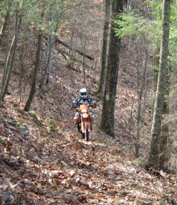
Here is Bryan near the start, at the Beginning of the Watersmeet trails.

The bikes taking a rest along a marsh

At one point along the rail grade trail, there was three long and tall old trail bridges, each bridge was seperated by a couple hundred feet, pretty neet section. Its amazing what they used to do by hand to build the railroad the haul out all the lumber and Copper from the U.P.
Here is a view from one of the bridges.

After pounding the ORV trails, and many miles of old railroad grade,
we get our first glimpse of the Keweenaw penninsula at the towns of Houghton and Hancock.

Cool drawbridge between Houghton and Hancock, a couple pretty nice little towns.

After pigging out in Houghton, we decided we were going to try to make it all the way out to the tip of the Keweenaw penninsula, a fairly lofty goal considering the time.
Near the town of Ahmeek, we were riding along through an old mining site when Bryan hits some bumps and jetisons his one gallon spare tank. I honk like a mad man but he is too far ahead and doesn’t hear me. I stop and pick the thing up, being the nice guy I am.
Well, just a little ways down the trail it goes in three different directions. I have no Idea which way bryan went..damnit. I saw a waypoint on the GPS to the left, so I took it. Well, it was the wrong way and I went all the way into a town and drove around a bit, expecting to find him waiting..he wasn’t.
I figured out my mistake after looking at the GPS and headed off the the next waypoint that crossed the highway I was on, a few miles up the road. along the way I stopped and talked to a couple atv’ers at a gas station, they hadn’t seen anyone go by..shit. Well, I find a visitors center with a picknic table and get out all my maps, to try to figure out what to do. I turned on the cel phone and there was a message from Bryan. I gave him my location, and we meet up 10-15 minutes later. Well that cost us about half an hour and it was getting close to dark. We found out about a campground nearby and headed out Seven mile point to the campground.
$17 for a tent site, $22 for a cabin with two beds..SCORE!

Not a bad place to camp eh??

Well, a trip like this is a good learning experience. One thing I learned alot about was loading a bike. I read on a popular motorcycle travel site that when loading a drybag, put your air mattress in first then let it spread out to the perimiter of the bag and put all your other stuff in the middle. Well, thats all fine and dandy..unless the goddamn tips of the hooks on the bungie straps rubs a series of holes through the drybag and air mattress. Luckily we had a cabin the first night, but 6 holes in a $70 thermarest..son of a bitch. Lesson learned.

Day 1 ended up being 260 miles, Not too bad.

Day 2

We cruise up to the tourist town of Copper Harbor for breakfast but make a little side trip first up the Brockway Mtn parkway, a pretty fun little ride.
Here is a cool old bridge in Eagle River 

Here is what you see from the bridge.

Here is Bryan checking out the view of Lake Superior from Brockway

Here is a shot of the lake from a ways down of Brockway. Notice the freighter out in the lake. The shipping channels are fairly close to shore and there are tons of shipwrecks all along the coast. 

Our goal after breakfast was to take a side trip out to the very tip of Keweenaw point, to visit an old NASA rocket range. This was one rough as hell section of trail, but very fun. Lots of rocks, ledges, mud, etc. 

Lifes a beach. 

Bryan showing some nice form through one of the many mud holes.

Once we got done goofing off out there it was already getting close to noon, and we hadn’t made any progress in the direction we were heading for the day. The route calls for back tracking the same stuff we rode yesterday for quite a while. Well, those trails were nothing to brag about, and they run right next to the highway anyways so we put in some road miles. We had to stop in Hancock to find a Motorcycle dealer to see if they had a couple mirrors and a speedo cable for the DRZ. We each neaded one mirror from low speed dump yesterday. Well, no luck on the bike parts but we did find a camping store that had a patch kit for my thermarest.

More day 2
The ride from Twin Lakes to L’Anse and on to republic was the best part of the ride I think. Pretty remote feel to the area.
Lots of little side trips today. Here is the Victoria Spillway

Not sure what Bryan is up to here but it looks like no good.

We tried to find the exact spot of the top of Mt. Arvon ( The highest point in Michigan ), but exteme logging in the area made it quite difficult. We actually rode through an area with some loggers working, I’m sure they were wondering what we were doing.
Here is me riding down Mt Arvon Then we had to put the hammer down to get some miles in. Awesome Forest roads that make 50-60 mph pretty easy to do

Sometimes you have to stop and take a look at the scenery though

11hrs28min and 280 miles later arrive in at Little Lake campground.

We actually did go southeast out of Twin Lakes to Alston then about half way to Sidnaw we went east on FR2276 to the Sturgeon River Gorge. We didn’t hike all the way in to the falls though, It was frikin’ hot and at that point we just wanted to keep moving. We also stopped at silver mtn and talked to a guy but decided to skip the 300 step hike up to where there used to be a lookout tower. This is about the only things we skipped on becuase we felt we had been doing too much goofing of and not enough riding.

If we woulda known it was going to be so nice I coulda left alot of crap at home…but at least I didn’t bring the laptop this time
Actually a little rain woulda been nice, It was dustier than hell.

Day 3

We headed out of Little Lake and into Gwinn for Breakfast. We had to make a detour from the route to avoid some road construction. We got back on track and and headed up to Munising to get gas and some camping supplies. After Munising is the Pictured Rocks National Lakeshore. We stopped by Twelve mile beach then headed up to Hurricane River on some really sandy roads.
Twelvemile beach 

Hurricane River 

Wheres the scantily clad ladies..what kinda beach is this anyways?

This area has an excellent backpacking trail near the beach, something like 38 miles long I think. Bryan has done it a couple times and said it was great.
Next stop, the Grand Sable Sand dunes. Bryan said they would be impressive and it certainly was.

In the above pic there is the Au Sable lighthouse.
There is a spot on the Dunes where in the hayday of logging they had a chute down the dunes that they would send the logs flying down the 300 foot dunes to the lake, where they would be floated out to ships.
Here is the area the chute used to be. 

Bryan checking out the chute. You can go down this but its harder than hell to get back up.

Heading out towards the Crisp Point lighthouse.

We gassed up near the mouth of the Little Two hearted river and had to either take a shortcut on the ORV trail or backtrack a ways to the gravel forest roads.
In this 3 mile section of ORV trail I dumped my bike 2 or 3 times. The sand was super deep and I had major issues. In the above picture I was busy screaming a series of expletives that woulda impressed anybody…it wouldn’t be the last time I did it either.

We finally make it to the Crisp Point lighthouse.

and off we go again on some better ORV trails and forest roads.

The next little side trip was Raco Field. Raco field is an abandomed military airstrip, built around WWII to protect the locks at Sault St. Marie. There are 3 runways each around 5000 ft long and built in the shape of a triangle.

Bryan scooting down the runway.

We pull into a camprgound near St. Ignace early and head out to a buffet then go grab some beer and head to camp. I spend the rest of the night trying to fix my thermarest and drinking some cold ones.
aahh

The whole time on the ride I was wishing I had a KTM 450 dual sported.
Bryans DRZ worked great, but so did my XR, well except for the sand. I’m sure the sand thing was mostly my fault but Bryan hopped on my bike and was suprised with the geometry. On the XR, you sit right on the tank, even when you slide back, you end up sliding forward because of the seat angle. The DRZ’s geometry is much more like a dirt bike. When you sit naturally on the bike, your arms are pretty straight, and your hips are probably 2 feet from the center of the steering tube.
I know the DRZ isn’t the greatest dirt bike either but its better than the XR. Heck, I think you could ride a GS or a V-Strom on most of the route, its pretty easy for the most part, but there are some sucker sections.

Its a pretty cool area. Its really hard to belive that something like this is possible anymore. Its staggering the amount of land up there. There was one section that I’m pretty sure I didn’t see a house for more than 30 miles! Everything was pretty laid back, the people and the weather were great, and it felt like we could do whatever the hell we wanted.
The Cycle Conservation club of Michigan ( http://www.cycleconservationclub.org/index.htm) actually has three things like this. The U.P. safari, the L.P. Safari ( which is also 1200 miles ) and the M.C.C.C.T. trail safari which is 500-800 miles depending on how you do it and is the longest permanently marked motorcycle trail on earth!

Day 4

By Sunday, we were getting pretty good at breaking camp and getting the bikes loaded. I think we were on the road by 7:30 and head into St. ignace for breakfast and to check out the big bridge.

Thats the Mackinac bridge, pretty impressive. 5 miles long, the tops of the towers are 522 feet tall and the roadway is 199 feet above the water.
Headed out on the trail and rode some pretty fun sections. At one point we took a wrong turn and rode about 5 miles of great trail that led to this.

Then we got to the Highwater truck trail 

Bryan goofing off 

After this area, the trail gained elevation and got real sandy. Remember what I said before about sand..yeah, I hated it. If I did this again I’d skip this whole section.

 It got to the point where I was just basicly pushing the bike, lugging it in first gear just barely moving. I really didn’t want to dump it on this section. It was quite hot and I was getting pissed.
I ended up surviving that section of trail and we pressed on.

But the sand wasn’t completely gone…

This was a hard drop. We were stopped trying to figure out where to go and found it was the other day than where we were pointing. I turned the bars, gave it some gas and tire washes out..BAM, down she goes. We got the bike back up and I hopped back on it but something was wrong. The bars were bent..Shit. I hopped off of it to take a better look and noticed that the fender wasn’t pointing the same direction as the tire either. What the hell..We reefed on the bars a bit and got them a little better but its still messed up.
portrait time.

Time for some rest and a snack 

And here we are, back at the start.

We head out of Iron River and stop in Laona and pick up some beer at the bar and head to the cabins near Wabeno, to celebrate our ride.
Day four ended up being 399 miles and we got to the cabin 15 hours and 15 min after leaving the campground in the morning!

Miscellaneous

Bryan was pretty quick with the camera whenever I did something stupid. Here, my kickstand didn’t go all the way down and tipped over when I got off it, landing on my foot

Notice where this happened..luckily I didn’t get tossed in the river.

Don’t think I was the only one to do something stupid

I just have an uncany knack to be caught doing stupid shit

Parting Thoughts

Chad ->

It was pretty cheap actually. You have to be a CCC member, which is $30 and you need to buy the Safari packet, which is $25 and includes your passbook and a CD with all the GPS info, Maps and other info. Then, you need a Michigan ORV stickers which is $16.75 I think.
There really isn’t alot of info out there about this trip, thats why I wanted to post some pics. Its a great trip with some awesome scenery, get out and ride it!

I fall down alot, I have a bit of a problem with deep sand. I do OK if the sand is only 2-3 inches deep, but when it gets real deep and tracked up, I have a tendency to wipe out. I’ve tryed about every technique out there, and they all end up the same way.

Bryan ->

Chad rides pretty well. I think it has more to do with the bike. I sat on it and it seemed like you were sitting on the front wheel. Maybe he should go with the DRZ after all . . .
And hey, some of that deep sand was really tough. The only redeeming factor was that sometimes there would be a small piece of good trail in between patches to let you get the bike trimmed back into coordinated flight before plowing into the next section of “turbulence”. Once you lost speed, it was a real struggle to recover.

Background – Even though we did it in four days, it was not a death march. We ate a leisurely breakfast sometime during the morning (restaurant – we didn’t cook), made side trips, and took a lot of breaks and photos. For dinner, we would pick up a sub and a couple of beers to enjoy at the campsite. If you keep moving at a reasonable pace you really rack up the miles. It probably should have been a five day ride for us but we got a little crazy the last day and rode out the finish just as it got dark. Take those side trips. If something interests you, go for it.

Consider this: if you stretch the trip out too long, it has the potential to turn into something boring or even become a chore. We stayed active and eliminated dead time by filling our days with a good mix of riding and tourist stops. The bottom line for us was that we like to ride and we came to ride, so we rode until we ran out of time, light, or ambition.

My DRZ-400S was stock except for the fresh set of DOT knobbies – and don’t those tires boost your confidence when your bike is swimming around under you in that soft sand or spongy gravel. Oh yeah, I also “upgraded” to a gel seat. This didn’t work out for me as the upgrade seems like I went from sitting on a concrete block to sitting on a railroad tie. When the beaded seat cover I ordered didn’t come in, I went to a discount store and bought the auto version for about seven bucks. I folded it into the shape of the seat using zip ties (you can’t cut the beads) and rode it the whole way. This thing kept me cool and dry – no monkey butt! Try it – you will like it. If not, the wooden beads would make a nice campfire along the route.

Clothing – I left my riding clothes at home and instead wore light backpacking trousers, a long sleeved shirt and desert boots. The theme was to keep cool and dry and it worked. I wore a sleeveless travel vest because I liked the easily accessible pockets. If it would have rained or if we would have had wet trail, I had a gore-tex rain suit and almost had gore-tex socks for my boots.
I wore a fleece lined jacket in the early morning and later evening when the temperature was between 50-70 degrees. If you don’t wear a jacket, you might want to wear a mock turtle neck tee shirt of a dust rag around your neck to keep those crunchy bugs you run into from going down the front of your shirt. Dark sunglasses won’t serve you well. You end up going from bright sunlight into a “forest tunnel” of dark shadows and it is hard to see the trail.

Camping/Packing – We took light sleeping bags and small tents. My air mattress, pillow, sleeping bag, tent, and extra clothes all rolled up into a compression stuff stack that I strapped to my luggage rack. I strapped a small lumbar pack around that for miscellaneous items. It took a day to learn how to pack everything securely. The lesson learned is that everything needs to be inside a bag. The whoops on the ORV trails cause you to jettison some things from your bike (like a can of chain lube, a water bottle, and assorted soft drinks in various stages of consumption). Put it all in a cheap stuff sack under some elastic cargo webbing. By the way, if you find one of my soft drinks, better wait until spring before you open it. It is probably still pretty fizzy from the paint shaker treatment it got on the whoops. I had a one gallon gas can for a while, but gave it up when I found out I didn’t need it at all. I also had a tow rope wrapped around my front fender – speaks for itself.

I ran 18/24 lbs in the tires. The couple extra pounds in the back was for the extra load. The bike rode well, even with the extra load, but was harder to handle standing still as it was more top heavy. Also, you can’t swing your leg over the back making getting on and off a chore. I had 5 or 6 good rock strikes. Sometimes you just can’t see them in the shadows or when just and edge juts up from the trail. Look out for wooden bridges too as the edges are sometimes exposed. I had heavy tubes and tire slime in both wheels. Chad and I had no flats.

Navigation – I had a Magellan Sport Track GPS mounted on the handlebar loaded with topo maps for the UP. I also loaded the waypoints from the CD but for some reason ended up with some big sections missing. Although I cobbed in a 12 plug for the GPS, I decided to go with a fresh set of AA batteries everyday instead. Saves on a lot of external power lost messages on the screen. I printed out the maps from the CD and put them in a waterproof 9X12 map case that I clipped to the crossbar with cheap key ring carabiners. I liked this because I could clip and flip the map over on the fly. I could display two full sheets at a time – one on each side. I also carried a DeLorme Gazetteer with the route highlighted on it. I put this in a jumbo waterproof map case and carabiner clipped it to my read cargo net. The Gazetteer is also great for map recons. The definition and detail is good and it shows a lot of area information regarding state and federal camp grounds and other items of interest. In an emergency it might be good for alternate routes and has lat/lon info in the margins. Road names vary from publication to publication and I attribute some of this to the “same road” having segments that have different names. The GPS pops up a window with road names (in addition to the names on the map) as you approach them – including the name of the road you are on. This is very handy. You have to be good enough with the GPS to operate it on the fly. You will have to zoom in and out a lot to get detail and look ahead for confirming waypoints. We had the waypoints starting out so they were great in confirming that we were following the route correctly. Later when we lost them, we were still OK because by that time we figured out distance, scale, and what each of the roads and trails might look like.

All that doesn’t mean you won’t still miss a few turns. Sometimes you are daydreaming and lose track of time/distance and mess up. If the trail you are on is more and more looking like less and less you are usually in the wrong place. Don’t get frustrated if you miss a few and have to back track. It happens to everyone. Instead, congratulate yourself on taking a scenic side trip in addition to the standard course and move on. These “exploratory moments” are actually kind of fun. You usually get an interesting ride.

The roads and trails vary. You can easily do 30-50 mph on much of the gravel and ORV trails. Some places slow you down to putt-putt speed (whoops, rocks, washouts, potholes). Roads that are also snowmobile trails are great because they have fabulous signage. Those that aren’t give you those adrenaline moments – you know, like when you are in the groove heading into a blind corner on a forest road when you suddenly realize that the road is turning much sharper than you are. Conveyor belts nailed to some bridge surfaces can be slippery. Echelon formations work good on most gravel roads to keep from powder coating the #2 rider. In narrow areas, a l-o-n-g trail formation will keep #2 out of the worst of the dust.

We didn’t run into a lot of traffic on the off pavement sections – even on Saturday. Deer seemed to be more present on the trails in the evenings although we saw a lot of them. I had no close calls but slowed down early when I saw one ahead.

Gas was not a problem. The longest stretch we had was 96 miles and I made that without going on reserve with my 2.4 gallon tank. Chad had a custom large tank and we had a siphon hose along just in case. That 96 miles would have been more like 80 but for a few “exploratory moments” on our part. We did have a problem with “intermittent” gas stops. One place had a note in the window proclaiming “no gas”. Others were closed. I usually gassed up when I got down a gallon or when I saw a very long stretch ahead. On one long run, the marked stations were closed. When I got close to a big town I already had about 90 miles on my tank and scoffed at an available station thinking I was packing sufficient cool to make it. Five miles out I hit reserve. I’m glad I did because now I can say that I had to go on reserve. We needed to be able to do that just to add drama to this story. We were short on harrowing tales of adventure because everything was going too well. Both Chad and I were often getting 50 mpg – except where the trail was tough.

Here is a basic route map.

uff da, that 4th day was a tough one!

Kentucky DS Ride

Kentucky DS Ride
by Terry Nestrick

I have composed a ride report for a Williamsburg, KY DS ride completed 28 to 30DEC06 by Terry Nestrick

[Toxic], Dan Djokovic [Indy] and Neal O’Brien [2big4akdx] … we basically rode a variety of roads, 2 trackers, trails, streams, mud holes, hills and valleys in the Daniel Boone National Forest west of Williamsburg, KY which is located at KY exit 11 of I-75, approximately 11 miles north of the KY / TN border. The link given below provides an interactive map of the area which can be expanded to illustrate the variety of roads and trails available in the forest area to the west of Williamsburg, KY … basically we mapped out an area of interest for each of three days riding on Indy’s Garmin 60CSx so as to provide an 85 to 110 mile ride, then we took off exploring … as is common with such rides, many routes proved to be dead ends, others started well and became impassable, some simply were not there any more, others were totally new and very exciting … but in the end, our goal of seeking a winter reprieve in the form of adventure riding was completely fulfilled. The weather was outstanding all three days … sunny, temperatures ranging from low the 40s to almost 60 … we needed cooler weather gear for an early morning start and could delayer throughout the day … even pavement sections were quite comfortable in the early AM with a decent pair of thermal gloves … we carried a reasonable assortment of gear to include tire repair implements, common tools and an extra air filter to cover the potential of swamping a bike in one of the many water crossings encountered in this area. Even though this is the low water time of year for KY, we still found streams that were much too deep to safely cross. Tire repair gear is a must as glass and metal fragments are quite common in the forest areas and also in many of the residential areas one must pass through on the way into or out of the forest … in fact, in our last trip to KY over Thanksgiving, Indy got a rear flat by something that produced a very clean cut through the center of his tire and tube [Teraflex tire with Bridgestone Ultra Heavy Duty tube] … we had better luck this time though, no flats! Each of our bikes is capable of at least 100 miles on a full tank of fuel for the expected type of riding … in some cases, depending on where our ride took us, gas stations were not available so appropriate planning was necessary … only the KDX-200 [2.9 gallon tank] came close to exhausting its fuel supply after a 96 mile ride on day two of the adventure … under these riding conditions, it appears that the 3.5 gallon tanks on both the WR-450 and the KTM 300 XC-W could easily provide greater than 125 miles range.

For those who might be interested, we opted to get a room at the local Super 8 Motel just off the freeway in Williamsburg … at a total cost of $50 per night split between the three of us it offered a perfect base from which to ride each day and provided a hot shower and clean bed each night with a complimentary Continental Breakfast each morning to boot! Amazingly, Williamsburg has virtually every brand of fast food known to man available in walking distance from the Motel … however, only one “sit down” type restaurant, of the Mexican persuasion … luckily, it is quite good and reasonably priced … located right next door to the Super 8 as well! One other point, there is a nice Quarter Wash [actually Dollar-and-a-Quarter Wash is more accurate] just over the freeway to the west on 92 … right on the way home each day … because of the negative characteristics of multiple coatings of dried-on clay, we stopped each evening and lightened up the bikes by several pounds with a quick spray wash followed by a good chain lubrication with Digilube … definitely raises the spirits to see your faithful steed emerge from the mud each evening and greet you each morning with a twinkle in her fenders; but now I’m waxing a bit too poetic for many I’m sure …

Indy [Dan Djokovic] is an expert at planning and conducting such adventure rides by combining his innate sense of direction with an ability to assess aerial photos available on line as further delineated by overlaying roadways and trails which are also available on line. Combining these items with some GPS tracks and ride descriptions posted on the Adventure Rider site he managed to keep us moving regardless of what the terrain had to offer. In fact, if one did not know him, you would swear he lives down there or has ridden down there many times before … not likely though since he is actually a Canadian whose ancestral lineage in my scientific opinion can be traced back to an extinct breed of homing pigeons! Indy preserved the details of our actual tracks and kept notes on his Garmin regarding many of our planned routes … if anyone is interested in such information, you can contact him at: <mailto:d2eng@comcast.net>d2eng@comcast.net. We are devoting a series of several 3 to 4 day rides over the next couple of winters to attempt the compilation of a series of GPS routes in the Daniel Boone National Forest which will provide reasonably exciting DS rides without having to suffer some of the complications associated with tough terrain and dead ends encountered when basically riding blind as we did in this particular case.

Basic Area Map of Williamsburg, KY:
Live Search Maps

Bikes:
Indy: [2004?] WR-450
Neal: 1996 KDX-200
Toxic: 2006 KTM 300 XC-W

Photo 1 … This is our first day’s ride … Neal won’t arrive until tomorrow so Indy and I are out testing the waters [+ clay = mud] to the west and south of Williamsburg, KY … that’s him going up the hill, not incredibly steep but far worse than this photo makes it look. We headed into the forest and began following roads and trails which pointed us in a southerly direction as we were planning lunch in Jellico, TN. Naturally, Indy who is an expert rider has a knack for picking the muddiest, steepest, slimiest trails he can find … here we are climbing up a mountain side on what is labeled a KY road … just before this shot I barely made it up a deep mud infested switchback only to become entangled in a 3″ plastic hose draped across the roadway over the top of a muddy section … all to the absolute amazement of Indy who always offers such sage advice as: “Why did you take the hardest line?” … or: “Never stop before clearing an obstacle!” … all the while I am struggling to get free of whatever situation I have managed to cause by my less than optimum riding skills. We ran into three hunters at this point, it is about 1100 hrs … they were riding a large utility ATV up to the top of the mountain to go bow hunting for deer.

Photo 2 … The smile shown here on Indy’s face usually appears just before the trail goes totally into the crapper … we have already been climbing several hundred feet to this point on a road that went from quite muddy to nice gravel … then, in the distance, you can see the rather interesting route to the top. We explored a short trail off to the left before this hill … it was a grassy 2T that led directly into a swamp after a few hundred yards … all just part of the adventure! We left our new hunter friends behind at this point … their ATV would have had problems climbing this hill.

Photo 3 … Trail at the top of our first mountain climb … sort of a cross between a single track ATV trail and a dirt 2T … although it’s difficult to see in this picture, the trail drops off of this mountain, goes through several switchbacks, then climbs up the next mountain centered in the frame. As long as we were at higher elevations the trails were quite dry … usually hard clay with large rocks present in the surface … the rocks occasionally formed the entire surface of the trail and gave me plenty of practice climbing and descending rocky stair steps and rock-filled erosion ruts. This area was relatively easy riding and quite fun … the greatest hazard was spending too much time looking at the scenery … more than once I nearly ran off the trail after becoming a bit too enamored with the real estate. This trail actually turned out to be a viable route as we later emerged on one of the many National Forest roadways and therefore didn’t have to backtrack through the particularly muddy climb previously described. Although not particularly evident in this shot, just off the side of the trail is an extremely steep incline … perhaps greater than 60 degrees slope most of the time and quite often, a sheer cliff … therefore staying on the trail is imperative to maintain one’s health!


Photo 4 … Here’s Indy blasting down one of the National Forest roadways … they are often a combination of pure gravel surface intermixed with sections of asphalt … we typically rode such areas at 25 to 30 mph … a nice comfortable speed to permit assessment of the scenery while still enjoying a bit of mechanical mayhem with the machinery.

Photo 5 … We ate lunch in Jellico, TN which is just over the TN border south of Williamsburg, KY. Jellico is actually outside the National Forest … here we are proceeding west out of Jellico and came across this ancient Jail … compared to some of the homes in the area, this old Jail is actually in pretty good shape.

Photo 6 … One of the typical National Forest roadways … this one is exceedingly well maintained despite being on a very steep, multiple switchback … the reason is quite simple, Indy is pointing at it … we are just inside the TN border and the adjacent KY county to the north is “dry” … yup, you guessed it … that’s the Rooster Scratch Bar and Grill just up ahead!

Photo 7 … It’s 1430 in the afternoon and the temperature is beginning to drop, especially in the valleys where you are in the shade. We are circling back to Williamsburg and are crossing one of the many streams in this area of the forest … luckily for me, Indy couldn’t find a trail that necessitated fording this creek, otherwise this photo might well have depicted something quite different … whenever entering water I usually picture two perfect rubber arcs protruding from the surface of still waters, perhaps the worst time one could imagine to have the rubber side up … only in the mind of a novice rider, eh?

Photo 8 … Many of the side roads leading into and out of the National Forest are asphalt similar to what is shown here. Actually I had a blast riding these smooth, lightly traveled, very curvy paved sections as I had not ridden on the road much prior to beginning DSing late this past summer. Per the suggestion of Indy, I equipped my KTM 300 XC-W with a Michelin Desert Front and a Michelin Baja Rear tire … aside from being nearly impossible to obtain this time of year, these tires appear to be working very well*** … they hook up nicely in virtually every situation I have encountered thus far [pavement, gravel, mud, rocks and sand] … and after approximately 750 miles the front is near virgin condition while the rear is just beginning to show a distinct, flat, center wear pattern on the knobs … they do not show any chunking or hair-line cracking of the knobs of either tire even though they have been subjected to high speed pavement running and considerable forays through rocky terrain. We stopped here for Indy to check our route back to the Motel on his Garmin.

[*** It is probably important to mention that because of my rather limited riding skills any assessment of tire performance mentioned herein should be taken with a large dose of salt or perhaps, alcohol … anytime I discover a brand that remains down more than up with respect to the rubber side, I tend to like and promote it.]

Photo 9 … Neal appears and the fearsome threesome is off for Day Two’s ride … Indy on the left, Neal in the center, Toxic on the right. It is 0930 hrs in the morning, there’s still a bit of nip in the air … and most importantly, the bikes are nice and clean … but not for long! Today we plan on riding due west across the breadth of the National Forest toward Stearns, KY to check out this relatively uninhabited area.

Photo 10 … That’s Indy … blasting through the first steam crossing of the day … this one is typical of the cement bottomed road crossings encountered throughout the National Forest … they are usually posted: “Do Not Enter Under High Water Conditions” … here the water level is about as low as it gets, only about a foot deep in the center. Turns out the biggest hazard on many of these cement crossings are places where the concrete has broken away leaving behind a web-work of rebar where sometimes the ends are protruding upward … the hole in the lower left of the photo is just such a spot.

Photo 11 … Many of the trails tend to follow ridges in higher elevations and, as shown here, streams and creeks in the valleys. I got a bit over zealous in photographing Mother Nature and almost didn’t show you any of the trail we were about to investigate … it is peaking out in the upper right hand corner of the frame … but wait, there’s more coming!

Photo 12 … Yup, you guessed it … Indy has succeeded again … first ‘adventure’ of the day … the wash job on the bike is trashed as we proceed down this rather messy looking trail that follows a small creek down the valley. We rode for quite some distance before the going became too arduous to consider fun any more[largely my opinion in this particular case] … then we backtracked through the whole mess a second time! From my novice perspective, what makes riding such trails as this one a form of gambling involves the high degree of variability associated with submerged surface composition … just when you begin to relax as most of the puddles are reasonably hard bottomed, you hit one that is pure, unadulterated, clay-based, slimy snot. Well, as you folks already know … and Indy is always reminding me: “Momentum’s your friend, unless you’re out of control” … perhaps, much like there is a very fine line between genius and madness?

Photo 13 … It is never too long before encountering another stream crossing … here we witness Indy demonstrating perfect riding technique for the foot deep water … good part is that you get rid of much of the mud you’re carrying after one of these! Most of the crossings are rock bottomed and therefore relatively easy to traverse … only the occasional larger stone causes any excitement. As mentioned previously, carrying an extra air filter and spark plug is prudent for such environs.

Photo 14 … Some trails were absolutely brutal! We opted out on trying this one … while it is difficult to assess the steepness of the incline in this photograph, take my word for it, this baby had all the makings of disaster written all over it! The erosion gully in the center was over 5 feet deep about half way up the off camber hillside … the erosion gully was sloped at greater than 60 degrees … the center was muddy clay mixed with rocks and then covered with leaves … yea, I can picture many of you folks right now … your tongue is hanging out, your palms are sweating, you’d give it a try … but patience my friends, we have a whole day ahead of us … its not nice to break your ride too early in the day!

Photo 15 … Indy [left] and Neal beneath a huge outcropping of sedimentary rock. Although all the leaves are now gone from the trees and the countryside is a bit washed out with regard to color, it does have one advantage … you can actually see more of the terrain. Indy has been down here in the summer and he tells me that when the trees are in full bloom, you can barely see any of the terrain such as this.

Photo 16 … Mile after mile of near perfect riding conditions … this is a T in the trail about half way up a mountainside that is actively being forested … the trail leading up to this point looked exceedingly fresh, was very rough, soft and muddy in spots … at one point we passed a foresting machine. As you can see, when it rains, it gets muddy very quickly … the conditions go from reasonably good traction to quite slippery because of the clay soil composition common to this area. The trail straight up the mountain in the foreground is my one failure … it is a series of switchbacks, each flight becoming steeper and more rocky until it finally emerges on the top where the road becomes ‘reasonable’ again … or so I am told by Indy and Neal, both of whom easily made the climb and profusely described it as: “GREAT FUN!” I simply ran out of momentum [and courage] about 80% up the hill … where I came to stop the hillside was so steep I couldn’t stand up … so, I slid off the back of the seat and held on to the bike for support … together we slid downward, first sideways, then finally in the forward direction … after three flights of bulldogging I managed to find a spot I could remount and restart my bike and ride the rest of the way back to this exact point.

Photo 17 … A great purview of the valley below … we are actually perched on the edge of a huge rock cliff and to my left, the trail runs directly up to, and if you’re not paying attention, off the edge … it was at least a 300 foot fall straight down!

Photo 18 … Early in the morning of Day 3 … today we head to the north and with intentions of following the Cumberland River west into the forest … we take a side adventure on a small single track leading off the main trail … it heads down a steep, rocky hillside and emerges in a hidden valley occluded by this gargantuan outcropping that Indy and Neal are posing beneath … but there are more secrets to unfold!

Photo 19 … The valley beyond the preceding outcropping is a box canyon serving up this delightful waterfall pouring into a perfectly formed, natural, reflection pool. All of this scenery is completely hidden from the main trail which skirts the valley on the ridge above the waterfall to the left. The temperature was at least 15 degrees cooler down in this natural depression which likely explains the many campsite remains in the area.

Photo 20 … Neal heading up another of the countless ATV trails … the pines add a great deal of color to the otherwise bland decor of the winter forest scene. As you might guess, there really isn’t much flat territory in the Daniel Boone National Forest. Many of these trails are dead ends but they still present a great deal of riding pleasure when you remember what MI can be like this time of year.

Photo 21 … I am posing within a giant cave leading into a rocky ledge alongside the trail. If you examine the upped edge of this ledge you can see that the soil layer is really quite thin … the vegetation and trees have developed a complex strategy of entanglement that enables them to cling to the mountainsides.

Photo 22 … Hey, a sandy road … feels a bit like Michigan! This is a KY road that follows the Cumberland River and appears quite well traveled … many spots folks can fish from along the bank.

Photo 23 … Oops! Another side trail turns ugly … here we see Neal assessing my chances of surviving an attempted ride down this gully … again, photography tends to forego depth as these rocky steps are really quite steep and lead to something even worse … check out the next photo!

Photo 24 … Here is the bottom portion of the trail before it climbs the other side of the gully … Indy and Neal are explaining the complex line I will need to take in order to arrive at the bottom while still alive and in control of most of my appendages. As indicated by the photography … my closest approach to this trail was via the telephoto viewfinder on my camera … that’s why I am still here reporting this ride to you!

Photo 25 … The three amigos nearing the end of another perfect riding adventure. In the background is the mighty Cumberland River … the sound of several nearby rapids can be heard above the resounding silence of the surrounding National Forest … definitely calling us to return in the near future. We hope that these photos and accompanying dialog have provided you a “taste” of our adventure and together we now share some of these experiences that only DS riders can truly enjoy!

Tennessee 2008

Tellico Plains Club Ride #1, March, 2008

MikeNGoatNot only did we ride them there trails, we took pictures as well.


The Cherokee National Forest in Tennessee has two designated horse/hike/Motorcycle trails. Trail 81 and Trail 82. These are not recommended for beginners (or flatlanders anyway). Both are relatively short linear trails. Each has a few climbs and a bit of side-hill off-camber action.

Believe it or not, we were there to ride the awesome backroads that wind along the mountains. These two single track trails were simply “hero section” options. Out of the several hundreds of miles of excellent, easy forest roads these two trails take up less than 12 miles together.

Special thanks to Kieth L for recording & sharing the video.

Video of Trail 82 (the easier trail). It had been raining the previous couple days making for a slippery ride. The rain came back about half way into the trail, which explains the blurred images.22 Minutes. Flash v8 Video, 80MB

Video of Trail 81 (much tougher trail). No rain today, just rain the last few days. Nice and sunny, with 4″ of wet leaves covering slick clay, loose rocks and the frequent roller log. This is only the first ~1 mile, the camera operator broke his wrist during filming, you’ll see. 7 Minutes. Flash v8 Video, 40MB

Video of various roads. Samples of what the paved and gravel/dirt roads look like. These are the roads we took from Tellico Plains to reach Trail 81. There are better ways (less pavement) but we had already used them on the previous days. 22 Minutes. Flash v8 Video, 86MB

About Falling

Falling while riding in sand is inevitable. With enough practice you too can become an accomplished soil sampler.

Here’s one of our yahoo’s in action. He had reached a blocked off 2T and attempted a standard turn around. Unfortunately (or fortunately for your viewing pleasure) the sand was a bit too soft and when the front popped off the sod it just plowed and stuck. Since the back tire was still higher up on the short ledge of sod there was just air under the riders right boot rather than the hoped-for firm footing. Obviously a more competent rider would have yanked on the bars and twisted the grip, but not this dude. Some folks simply exist to serve as a lesson for others.

The best part is the bike doesn’t stall, stays in gear (no autoclutch) and the rider is able to recover and escape the scene before anyone sees him. If nobody sees it, it never happened, right? 30 Seconds. Flash v8 Video, 2MB

About Tuck n Roll

Falling while riding in sand is inevitable. With enough practice you too can become an accomplished soil sampler.

Here’s a professional in action. Note the right side bar clip the tree to throw off his rythym followed by a quick dab to the left to increase air time. Follow it up with a tuck & roll in the soft sand and confirm the camera was recroding for extra credit. Lesson learned – don’t let the camera dude follow you.

No harm, no foul. Little O Trail. Mike W piloting. 15 Seconds. Flash v8 Video, 1MB

Whiskey Creek Classic 08 Video

Whiskey Creek Classic

AMA National Dual Sport; June, 2008

Video (below) provides a good overview of the type of routes in use at the Whiskey Creek Classic. Some trail, a little road and lots of two tracks. Scenic riding. Terrain is mostly sandy. Mostly forested with a mix of pine and hardwoods typical to western Michigan. 5 Minutes. Flash v8 Video, 17MB


Dave & Bruce run to Oshkosh

The Big One – aka Oshkosh ’08

by Dave Brock

We’ve always called it the Big One, any motorcycle ride leaving from home and returning in a big loop. Back in the ’70s we did the CCC Trail Safaris a few time, the best were leaving from home with tent and sleeping bags. When Bruce suggested we go to the Oshkosh Airventure, I was ready. Our plan was to ride to Ludington, cross Lake Michigan on the ferry, leave our tent and sleeping bags with Bruce’s cousin at the air show. He has a trailer there and volunteers for the EAA , we’ve always been interested in planes and such.

So this trip was going to be exciting, we get to see the War Birds, home builts, vintage, and helicopters. The next step was to ditch the tent and sleeping bags and continue on to the U.P. and ride some of the CCC’s U.P.D.S. which we had done in ’02 and ’04. When we get the Bridge, we continue on to some of the trails from the CCC’s L.P.D.S. that we had done in’06 down to U.S. 10. From there we’ll try to dirt roads the rest of the way home. I tried to lay the routes from home to Ludington and US 10 to home on dirt road as much as possible using MapSource Roads and Rec.

Day 1. We head out north and west through Waterloo area, lots of dirt roads and on through farm land then to Manistee N. F. What I remember the most in the farm land are the smells, fresh cut hay, sweet clover, onion fields and of coarse dairy farms. One pleasant suprise, we cross the Flat River through one of the few covered bridges in Michigan. 291 Mi., crowded seat with the tent and sleeping bag.

Day 2. We line up on the dock in Ludington to board the S.S. Badger with about 40 road bikes, some headed to Sturgis Bike Week. Good weather, smooth sailing, not much to do on the Badger. I left my GPS on to record the course to Manitowoc. Average speed 15 MPH.- 60 Mi. Off load the Badger onto US 10 to US.41 to Oshkosh. We set up the tent at Jim’s trailer while the Goodyer Blimp is overhead. So many planes of all sort to see!!! 139 Mi.

Day 3. We get up early to try to see as many planes as possible in our one day lay over. There are trams and buses to take us to the different types of planes. War Birds, B-17, B-24, B-25, B-26, T-6, P-51, P-38, F-86, Mohawk, Caribou, F-15, F-16, F-22 (star of the show). Military cargo and refueler jets.Even some Russian Migs. Only one Huey H model (disappointing I worked on them  in Viet Nam), Seahawk(Navy version of a Blackhawk) Osprey, Bell 47 and civilian Rotorways. Red Bull Europian helicopter ( I don’t know the type). Many vintage Bi-wings, High wings, sea planes. So many personal plane and ultra lights. They have 3 Bell 47 flying continuesly. I’ve got go for a ride in one!!! They have a really neat museum there and we spend a couple of hours in. >From 3 to 6 in the afternoon they have an air show every day, loops, rolls, smoke, explosions, and flying in formation. The star of the show is the F-22 doing amazing things that defy gravity plus flying in formation with a P-51 Mustang. this event is very well organized, they have 1200 port-a-johns – no waiting.

Day 4. We get rid of the tent and sleeping bags, more room on the bikes and head north to the U.P.. We get off of US 41 onto secondary roads. It rolling farm land to Lena, Wi. to visit Bruces 94 Yr. old aunt and cousins. We leave Lena and head north again and soon we see an eagles nest on a power line.We’re getting closer to the U.P. when we stop for gas we talk to some guys on crotch rockets, they’re going the same way and we meet them again, one them with a flat tire. One of them went back to get some tire plugs but they have no way to pump up the tire. I have a Slime Pump on my bike and Fix-a-Flat and we get them going again.(No good deed goes unpunished!!!)  We finally get to gravel roads in northern Wi. Almost to Florence and Crystal Falls Mi. 221 Mi. Motels and showers!!

Day 5. The quest for Mt. Arvon!! We were on two previous U.P.D.S. rides and we were unable to find Mt. Arvon. We left Crystal Falls on snowmobile trails until we got to gates, so we didn’t go around them but went out to the highway to Champion. We were back on track up to Mt. Arvon from the south side only to come to dead ends,I had layed the route out With Roads and Rec. but you can’t always go by whats on Roads and Rec. There is alot of logging going on in that area, making thing kind of confusing so we go to the north side of Mt. Arvon and find blue arrows leading the way. We reach the summit and sign the log and take pictures then continue on. Heading to Marquette we see alot of blueberry pickers. We’re almost to US 41 and I go on reserve and when we stop at 41 my bike stalls and won’t start!!! Bruce tows me down the road to a gas station and we gas up. The bike still won’t start, so we change the plug, tinker with the carburetor and wear down the battery!!! So Bruce says there’s a Walmart up the road and he goes and gets a new battery. We install it and we’re back in business. (Remember no good deed…..) 162 Mi.

Day 6. We leave Marquette on snowmobile trails to Gwinn and then on Gladstone and then U.P.D.S. route to Newberry. 256 Mi.

Day 7. From Newberry to Rexton then on to St. Ignace. In St Ignace we replace a nut and bolt on Bruce’s luggage rack. Some photo op at the Mackinac bridge then on to Bluffs at Black Lake for lunch. Off again to Mio on L.P.D.S. route. The hot tub at the motel in Mio feels pretty good!!! 252 Mi.

Day 8. While in the area, We head to the snowmobile trails to Lumbermans Monument on The Au Sable River, always a good ride. Then to St. Helen and   south through the Gladwin area. We get back US 10 area and it looks like rain so we go to a motel in Midland. After we unload at the motel, it rains a couple of times through the night. Got lucky again!!! 257 Mi.

Day 9. Not many dirt road south of Midland until we come across gravel roads heading south. We manage to keep on dirt about 50% of the way home!!! 164 Mi.
1741 MI. Total 218 MI. AVG. per day. Moving AVG.-29.39 MPH. AVG. MAX.- 51.52 MPH. Moving AVG. – 7.25 HR.. Stopped AVG.- 2.49 HR.

More Photos from this ride

Another excellant ride with no major break down and no rain!!!

Chandler Hill Challenge, September, 2008

Chandler Hill Challenge, September, 2008


Video (below) of the Chandler Hill Challenge Dual Sport course. Includes selected sections of MCCCT, ORV Trail, two tracks (that go on and on) and some “obscure” two tracks. 5 Minutes. Flash v8 Video, 17MB